
Primary Keywords: GIS, Geographic Information System, GIS Mapping, Spatial Data, GIS Software
Geographic Information Systems, commonly known as GIS, have quietly become one of the most influential technologies of the modern era. From the navigation app on your phone to the systems that help cities plan new roads, manage utilities, and respond to natural disasters, GIS powers an enormous range of decisions that shape our physical world. Yet many people who benefit from GIS every day have never heard the term or fully understood what it involves.
This guide explores what GIS actually is, how it works, and why it has become an indispensable tool across industries ranging from urban planning to agriculture, logistics, and environmental management.
Table 1.1 — Core Components of a Geographic Information System
| Component | What It Provides | Example |
|---|---|---|
| Spatial Data | Location & shape of geographic features | Points, lines, polygons, satellite imagery |
| Attribute Data | Descriptive info linked to spatial features | Store name, revenue, population count |
| GIS Software | Tools to capture, analyze & display data | Desktop, web & cloud GIS platforms |
| Hardware & Collection Tools | Methods to gather spatial data | GPS receivers, drones, satellites |
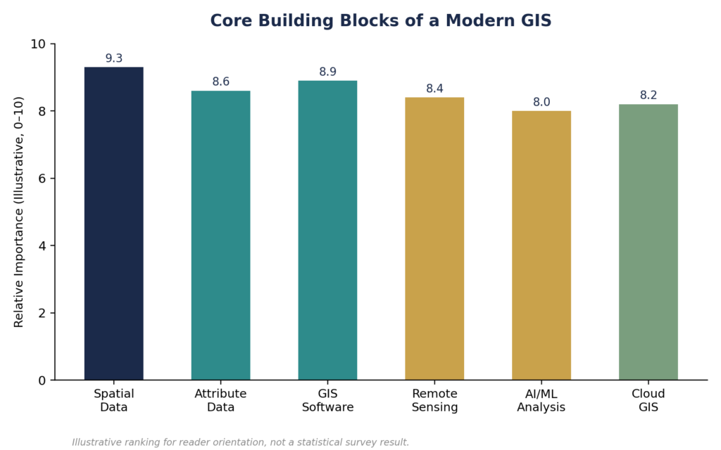
Figure 1.1 — Relative importance of the core building blocks of a modern GIS.
Defining Geographic Information Systems
A Geographic Information System is a framework for gathering, managing, analyzing, and visualizing data that has a spatial or geographic component. Unlike a simple digital map, GIS combines location data with descriptive information — known as attribute data — allowing users to see not just where something is, but also detailed information about what it is, its characteristics, and how it relates to everything else around it.
At its core, GIS answers questions that are fundamentally spatial in nature: Where are the most flood-prone areas in a city? Which delivery routes are most efficient? Where should a new hospital be located to serve the greatest population? GIS provides the tools to answer these questions with precision and visual clarity.
The Core Components of a GIS
Spatial Data
Spatial data forms the foundation of any GIS, representing the geographic location and shape of features on the Earth’s surface. This data typically comes in two primary formats: vector data, which represents features as points, lines, and polygons, and raster data, which represents information as a grid of cells or pixels, commonly used for satellite imagery and elevation data.
Attribute Data
Attribute data provides the descriptive information linked to spatial features. For example, a point representing a retail store might include attributes like store name, square footage, annual revenue, and operating hours. This combination of “where” and “what” is what makes GIS analysis so powerful.
GIS Software
GIS software provides the tools needed to capture, store, manipulate, analyze, and display spatial data. Modern GIS software ranges from powerful desktop applications used by specialists to intuitive cloud-based platforms accessible to non-technical users through a web browser.
Hardware and Data Collection Tools
Behind every GIS dataset is a chain of hardware used to collect and process spatial information, including GPS receivers, satellite imaging systems, aerial photography equipment, and increasingly, drones equipped with high-resolution cameras and sensors.
How GIS Mapping Works
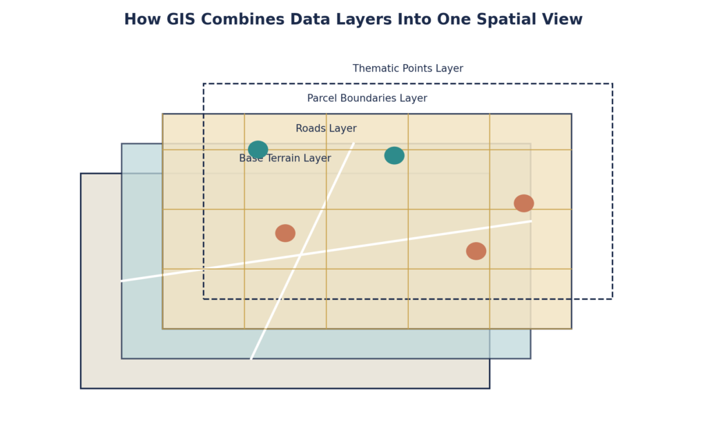
Figure 1.2 — GIS combines multiple spatial data layers into a single unified view.
GIS mapping begins with the collection of spatial data from various sources, including satellite imagery, aerial photography, GPS surveys, and existing datasets from government agencies or private organizations. This raw data is then processed, cleaned, and organized into layers — each representing a different type of information, such as roads, buildings, water bodies, or administrative boundaries.
These layers can be combined and analyzed together, allowing GIS analysts to identify patterns, relationships, and trends that would be difficult or impossible to detect by examining the data separately. This layering capability is one of the defining features that distinguishes true GIS from simple digital mapping tools.
Types of GIS Maps and Their Applications
GIS supports the creation of many different types of maps, each suited to particular applications. Thematic maps use color, symbols, or patterns to represent specific data variables, such as population density or income levels, across a geographic area. Topographic maps represent the physical features of terrain, including elevation, slope, and natural landmarks, essential for engineering and environmental projects. Cadastral maps show property boundaries and land ownership information, critical for land administration and real estate. Choropleth maps use shading or color gradients to represent statistical data aggregated by geographic region, commonly used in demographic and public health analysis.
The Evolution of GIS Technology
GIS has evolved dramatically since its early development in the 1960s, when the technology was primarily used by government agencies and research institutions with access to expensive mainframe computers. Today, GIS technology has become dramatically more accessible, powerful, and integrated into everyday tools and workflows.
Cloud-Based GIS Platforms
Modern GIS has shifted significantly toward cloud-based platforms, allowing organizations to store, process, and share massive spatial datasets without maintaining expensive on-site infrastructure. Cloud GIS also enables real-time collaboration, allowing distributed teams to work with the same up-to-date spatial data simultaneously.
Artificial Intelligence and Machine Learning Integration
Artificial intelligence is increasingly being integrated into GIS workflows, automating tasks like feature extraction from satellite imagery, predicting spatial patterns, and identifying anomalies within large geospatial datasets. Machine learning algorithms can now automatically classify land use types from aerial imagery, a task that once required extensive manual analysis.
Drone and UAV Mapping
Unmanned aerial vehicles have transformed how spatial data is collected, particularly for smaller-scale, high-precision mapping projects. Drones equipped with high-resolution cameras and LiDAR sensors can capture detailed spatial data quickly and cost-effectively, making them increasingly popular for construction site monitoring, agricultural analysis, and infrastructure inspection.
LiDAR and 3D Mapping
Light Detection and Ranging technology, commonly known as LiDAR, uses laser pulses to measure distances and create highly accurate three-dimensional representations of terrain and structures. LiDAR has become an essential tool for applications ranging from floodplain mapping to forest canopy analysis and urban 3D modeling.
Real-Time GIS and IoT Integration
The integration of GIS with Internet of Things sensors has enabled real-time spatial data streams, allowing organizations to monitor conditions like traffic flow, environmental quality, and infrastructure status as they change, rather than relying solely on periodically updated static datasets.
GIS Applications Across Industries
Urban Planning and Government
Local governments rely heavily on GIS for land use planning, zoning administration, infrastructure management, and emergency response coordination. GIS allows planners to visualize how proposed developments will impact traffic patterns, utility capacity, and environmental resources before construction begins.
Environmental Management
Environmental scientists use GIS to track deforestation, monitor water quality, model climate change impacts, and manage protected natural areas. The ability to layer multiple environmental datasets over the same geographic area provides critical insights for conservation planning.
Agriculture
Precision agriculture relies heavily on GIS technology, combining satellite imagery, soil data, and weather patterns to help farmers optimize planting, irrigation, and fertilization strategies at a highly granular level, sometimes down to specific sections of a single field.
Business and Retail
Retailers and logistics companies use GIS for site selection, delivery route optimization, and market analysis, identifying optimal locations for new stores based on demographic data, competitor locations, and traffic patterns.
Public Health
Public health officials use GIS to track disease outbreaks, identify areas with limited healthcare access, and plan the distribution of medical resources based on population density and health risk factors.
The Growing Importance of Geospatial Data Literacy
As GIS technology becomes increasingly embedded in decision-making across virtually every sector, geospatial data literacy has become an increasingly valuable skill. Understanding how to interpret and work with spatial data is no longer limited to specialized GIS analysts but is becoming relevant for professionals across urban planning, business strategy, environmental science, and public policy.
Choosing the Right GIS Solution
Organizations considering GIS adoption face an increasingly diverse landscape of software options, ranging from comprehensive enterprise platforms to specialized tools designed for specific industries or use cases. Key considerations include the complexity of required spatial analysis, integration needs with existing systems, budget constraints, and the technical expertise available within the organization.
Many organizations find success starting with cloud-based GIS platforms that offer lower upfront costs and easier implementation, then expanding to more sophisticated tools as their spatial data needs and technical capabilities grow.
Final Thoughts
Geographic Information Systems represent a powerful convergence of data science, cartography, and spatial analysis that has transformed how organizations understand and interact with the physical world. From the fundamental building blocks of spatial and attribute data to cutting-edge applications of artificial intelligence and drone technology, GIS continues to evolve at a remarkable pace.
Whether you’re involved in urban planning, environmental management, business strategy, or simply curious about the technology behind the maps you use every day, understanding the fundamentals of GIS provides valuable insight into one of the most influential technologies shaping our modern world.